The condition of peat swamp forests in South East Asia is a key driver of the tropical forest fires that affect more than 20 million people in the region as well as contributing to global CO2 emissions. Better management of peatlands to reduce fire frequency and impact depends on effective observation and monitoring of peat condition across a huge area of more than 250,0000km2. The Peatland Assessment in SE Asia by Satellite (PASSES) project uses state-of the-art satellite technology to monitor peat condition in Indonesia and Malaysia. Triple Line provided monitoring, evaluation and learning (MEL) expertise to track project performance, and provide evidence for the commercial viability of PASSES technology.
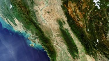
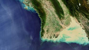
The importance of good management of the peat ecosystem in South East Asia was highlighted by forest fires in 2015, which affected 20 million people and released more than one billion tons of CO2 into the atmosphere. For peat restoration and conservation to be effective, accurate and up-to-date mapping of South East Asia’s vast peat forests is essential. The PASSES project aimed to provide cost-effective and reliable mapping data for stakeholders in Indonesia and Malaysia with cutting-edge satellite imaging technology that can measure peatland subsidence through dense forest canopies.
Triple Line provided monitoring and evaluation services as part of a consortium led by earth observation specialists at CGI UK Ltd, supported by the UK Space Agency’s £152 million International Partnership Programme (IPP). The project was based on a core innovative component comprising an Intermittent Small Baseline Subset (ISBAS) satellite radar data processing technique, which is the proprietary product of consortium partner Terra Motion. Other members of the PASSES consortium were the University of Leicester, University of Nottingham and Liverpool John Moores University.
PASSES used cutting-edge satellite imaging technology to monitor peatland condition and measure subsidence through dense forest canopies
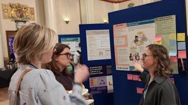
PASSES was a complex international project involving several planned stages from product design through consultation with stakeholders, to adapting PASSES products into publicly available mapping resources. Triple Line’s role in the consortium was to monitor the progress of the project towards the achievement of its objectives, to inform management decisions and assess the impact, relevance, effectiveness, sustainability and efficiency of the PASSES project. Building on our ongoing MEL support to the UK Aid funded Forest Governance, Markets and Climate (FGMC) and Forestry, Land-use and Governance in Indonesia (FLAG) programmes, our team brought relevant MEL, forest governance, gender and project management expertise as well as on-the-ground networks and expertise in Indonesia from our many years of working on forest governance in the country.
Our challenge was to design and implement MEL activities to meet both the immediate needs of the PASSES project in tracking progress and providing evidence of achievements, as well as the overarching needs of the IPP programme to evaluate and communicate its impact on development challenges around the world. Our methodology needed to align with a common IPP methodology allowing results to be aggregated to speak about the collective impact of the full IPP portfolio. Our MEL design was therefore framed by common processes, a common approach to evaluation based on UK Treasury Magenta Book criteria for process, economic and impact evaluations as well as OECD DAC criteria, and a common framework for understanding impacts, aligned to the UN Sustainable Development Goals (SDGs). The process therefore revolved around key milestone deliverables including baseline, midline and endline evaluations as well as a cost-effectiveness analysis.
We worked closely with the IPP’s MEL partner to refine the project theory of change and results framework; and conducted a gender analysis feeding into a gender strategy to ensure M&E of the project’s progress and performance in addressing gender equality, and gender-sensitive MEL. Evaluation activities included a wide array of qualitative and quantitative research methods including surveys, workshops, interviews, focus group discussions and document review.
Three in-depth client-facing reports analysed all aspects of the project against OECD DAC criteria and incorporated gender analysis, political economy analysis and clear recommendations for the client and the PASSES consortium. In addition, the team produced a final cost effectiveness analysis based on models of alternative scenarios, and a case study document which presented findings to a wider public audience. These outputs allowed the consortium to reflect on and adjust their approach to be more effective and efficient throughout the project, and also contained invaluable information for future projects using PASSES technology, helping them to maximise their impact in the future.
PASSES has successfully demonstrated the capability to generate preliminary satellite-derived products providing landscape scale observations of peat surface motion and a characterisation of the landscape. These products have the potential to inform low carbon development programmes, enhanced peatland restoration planning and assessment, plantation-scale water management strategies and plantation-scale evidence of sustainability compliance. Our final evaluation has found that there is scope for further development of the products and development of marketing strategies to explore interest from potential users.
Credit: photos by the European Space Agency
Licensed under the Creative Commons Attribution-ShareAlike 3.0 IGO license.